This shapefile contains the polygon layer that…

[pacificdata.org](pacificdata.org) – the Pacific Data Hub – is the central repository of open data and knowledge products about the Pacific region. Anyone can access the public data on the Pacific Data Hub. You are encouraged to search, reuse and share the data on pacificdata.org.
The Pacific Data Hub holds a large and diverse collection of data, data insights, publications, and knowledge products on the Pacific across key sectors, including population statistics, fisheries, geoscience, agriculture, aquaculture, energy, education, human rights, climate change, and oceans, and it continues to grow.
While the intention is for the Pacific Data Hub to become a multi-stakeholder-owned and managed platform, it is currently a product of the Pacific Community (SPC), and as such is governed by SPC’s internal documents.
Let us know how you are using the data hub or if you wish to contribute to our data catalogue.
For more information, please contact the Pacific Data Hub Project Team at [email protected].
License
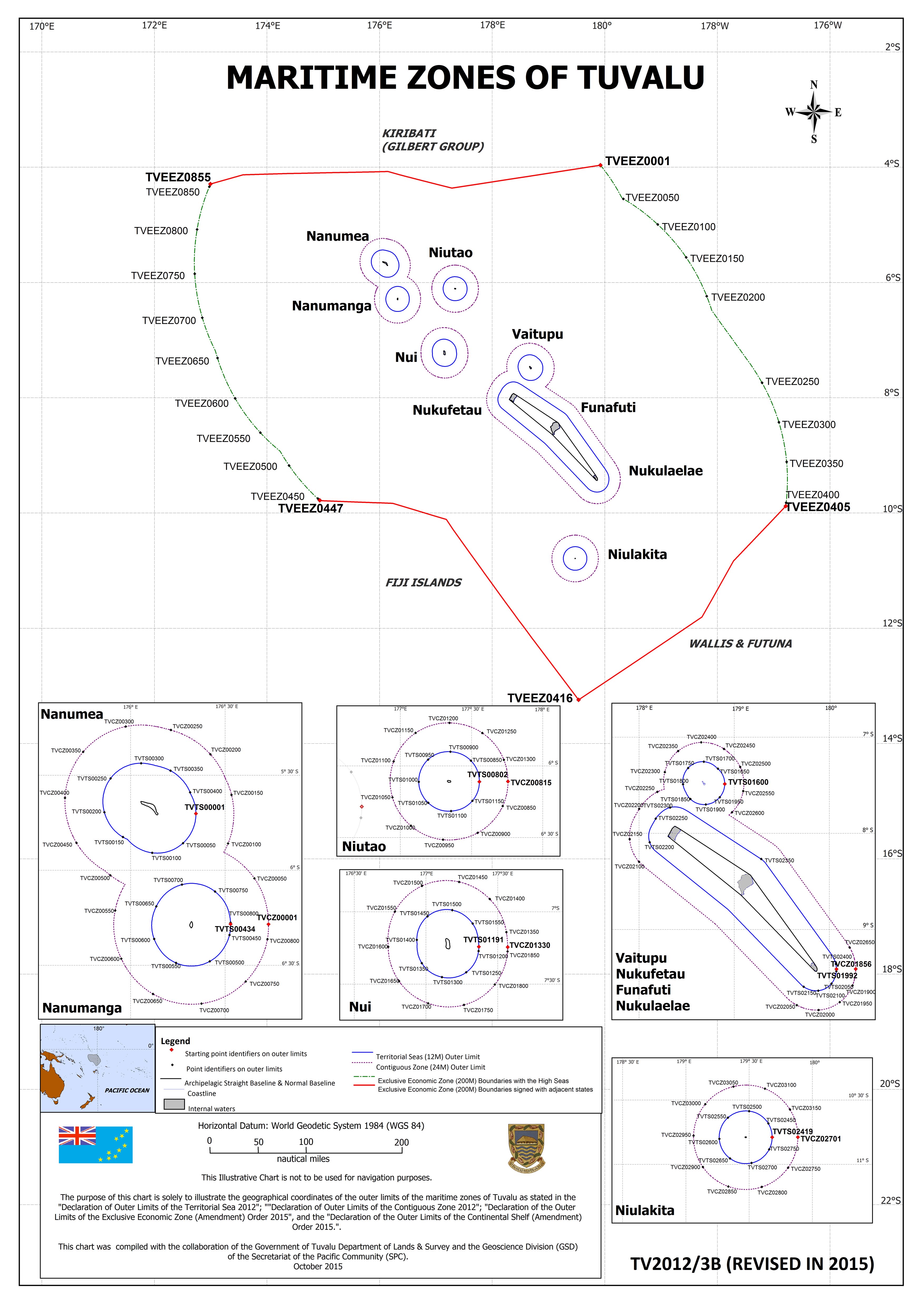
Part 2 of the Tuvalu Maritime Zones Act 2012 states that the contiguous zone comprises those areas of the sea that are beyond and adjacent to the territorial sea, having as their outer limits a line measured seaward from the baseline every point of which is distant 24 nautical miles from the nearest point of that baseline.
Where an archipelagic baseline is declared, the outer limits of the contiguous zone are a line measured seaward from that archipelagic baseline, every point of which is distant 24 nautical miles from the nearest point of that archipelagic baseline.
In addition, the Declaration of Contiguous Zone 2012 made under the MZA 2012 contains the geographical coordinate with reference to the World Geodetic System 1984 (WGS 84). The MZA of Tuvalu clearly illustrates in a map the contiguous zone of Tuvalu.
https://www.un.org/depts/los/LEGISLATIONANDTREATIES/PDFFILES/MAPS/TUV_M… https://www.un.org/depts/los/LEGISLATIONANDTREATIES/PDFFILES/tuv_mariti…
Data and Resource
Tuvalu CZ (24NM) _ Polygon (shapefile)
| Field | Value |
|---|---|
| Publisher | Pacific Data Hub |
| Modified | 19 May 2022 |
| Release Date | 24 December 2012 |
| Source URL | https://pacificdata.org/data/dataset/74006988-19c1-40ea-b8c0-d4a8ea6b85fd |
| Identifier | 74006988-19c1-40ea-b8c0-d4a8ea6b85fd |
| Spatial / Geographical Coverage Location | Array |
| Relevant Countries | Tuvalu |
| License |
Public
![[Open Data]](https://assets.okfn.org/images/ok_buttons/od_80x15_blue.png)
|
| Author | Array |